
Canyon Creek Trail
General Information
•Mileage: 3.5 miles one way
•Elevation: 2300 to 2000 feet
•Difficulty: Easy
•Use Level: Light
•Season: Usually all year
Access
From Downieville, follow Highway 49 west for ten miles to the trailhead at the Shenanigan Flat Road on the north bank of the North Yuba River just before the highway bridge. Park here but do not block the gate. Shenanigan Flat is an active mining area and authorized miners may use the road to reach their claims and camps.
Trail Description
The route follows the old dirt road above the North Yuba River for two miles. It passes through an area where miners are allowed to camp; please do not disturb any equipment or take anything even if it looks abandoned. The road ends at Cherokee Creek where a new footbridge spans the creek. Across the bridge the route continues as a trail. A few hundred feet beyond the bridge is the Brandy City Trail which has been used since 1850. Presently it is not maintained. The Canyon Creek trail follows the contour of the North Yuba River quite a distance above it and passes through Douglas Fir and oak woodland. It is mostly level all the way to where the trail ends at Canyon Creek, a creek almost as large as the North Yuba River! This confluence is quite exciting when the water is running high. Views of both canyons are impressive with or without high water.
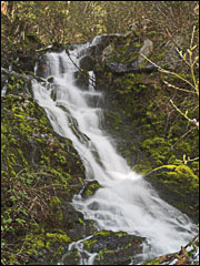
For a great waterfall hike, take the hike to Loves
Falls.
For an easy family hike, check out the Sand
Pond Interpretive Trail.
For a real challenge, there's Sierra
Buttes Lookout.
For a panoramic view, choose the Lakes
Basin Ridge Trail.
For enchanting forests and rushing creeks, try the Second
and Third Divide Trails.